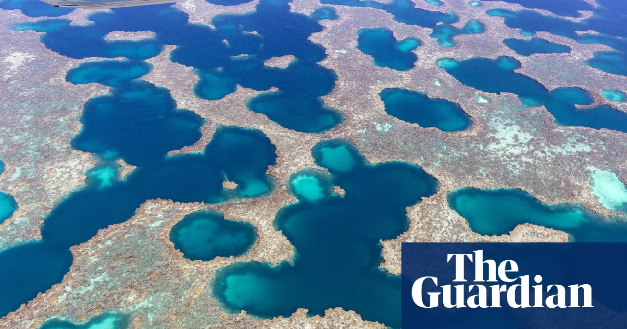
Aerial Photographer Captures Western Australia's Salt Flats
Martine Perret's five-year aerial photography project reveals salt flats, ancient riverbeds and marine biodiversity across Western Australia's midwest
A Five-Year Project Across Western Australia
French-born photographer Martine Perret has spent the last five years documenting the sweeping landscapes of Western Australia's midwest from above. Her aerial images capture ancient riverbeds that have carved the land over millennia, immense salt flats reflecting extraordinary colors, and a unique marine biodiversity across the Abrolhos Islands, Gascoyne, and Wheatbelt regions. The project reveals landscapes that are invisible from the ground, patterns that only emerge when the viewer is hundreds of meters above the earth. Perret's work belongs to a growing tradition of aerial photography that uses altitude as a tool for environmental revelation, following in the footsteps of artists like Edward Burtynsky, whose large-scale industrial landscapes transformed how audiences understand the relationship between human activity and the natural world.
The series builds on Perret's earlier work as a United Nations photographer, where she documented conflict and post-conflict environments across the globe. Her transition to aerial landscape photography was driven by a desire to engage with the Australian landscape at a different scale, one that reveals both its geological history and its environmental fragility. The salt flats she photographs are not static features but dynamic systems, changing color and texture with the seasons, rainfall, and shifting light. Prints of her work are available through her online print store, which offers archival prints from the midwest series and other projects.
Perret's approach to aerial photography is distinct from the clinical, survey-style aerials common in environmental science. Her images are composed with a painter's eye for color and a documentarian's instinct for narrative. Rather than presenting the landscape as data, she presents it as experience, inviting the viewer to share in the wonder of seeing patterns that have been forming for millions of years. This places her work in a tradition that includes artists like Fay Godwin in Britain and Emmet Gowin in the United States, both of whom used aerial photography to blur the line between documentary and fine art. Perret's contribution to this tradition is a sustained focus on a specific region of Australia, building a body of work that documents not just a single flight but a multi-year engagement with a landscape that continues to change.
What the Images Show
The photographs reveal landscapes that look almost alien in their abstraction. Salt flats, formed when ancient seabeds evaporated, create vast reflective surfaces that shift between white, pink, orange, and deep red depending on the mineral content and the angle of the sun. Ancient riverbeds, dry for much of the year, trace sinuous patterns across the terrain, revealing watercourses that have shaped the land over tens of thousands of years. The aerial perspective makes these geological features legible in a way that ground-level photography cannot, turning landscape into pattern and pattern into meaning. Some of the most striking images show where salt flats meet agricultural land, creating a visual border between the natural alkaline landscape and the green of cultivated fields.
The Abrolhos Islands, a chain of 122 islands and coral reefs off the coast of Western Australia, feature prominently in the series. The islands are surrounded by some of the most biologically diverse marine environments in Australia, and Perret's aerial images capture the transition between land and sea, the coral reefs visible through turquoise water, and the seabird colonies that depend on these ecosystems. The Gascoyne and Wheatbelt regions offer a different kind of drama, with agricultural patterns visible alongside natural geological formations, creating a visual dialogue between human land use and ancient natural systems. The images raise questions about how humans have shaped the landscape and how the landscape, in turn, shapes human activity.
What makes these images particularly effective is their refusal to settle into a single register. Some images are purely abstract, reading like paintings with no recognizable subject matter, while others are clearly documentary, showing specific features of the landscape with scientific precision. The tension between these modes gives the series its energy. A salt flat photographed at noon might look like a Rothko color field, while the same location photographed at dawn reveals the texture of crystallized minerals and the tracks of animals that have crossed the surface during the night. Perret's achievement is to show that the same landscape can be both abstraction and document, and that the difference is often a matter of light and timing.
Aerial Photography as Environmental Witness
Perret's work arrives at a moment when aerial photography has become one of the most powerful tools for environmental storytelling. Photographers like Edward Burtynsky have demonstrated how the aerial view can reveal the scale of industrial extraction and environmental transformation in ways that ground-level images cannot. Perret's approach is less didactic but equally urgent. By showing the beauty and complexity of these landscapes, she makes a case for their preservation without resorting to explicit activism. The images are part of an ongoing series, and she continues to add new locations to the project. For readers interested in the broader context of aerial and environmental photography, Colossal regularly features aerial work from artists worldwide.
The timing of the publication is significant. Western Australia's midwest is facing increasing pressure from mining, agricultural expansion, and climate change. The salt flats that Perret photographs are not only visually striking but ecologically sensitive, supporting unique microbial communities and serving as indicators of hydrological change. By documenting these landscapes from the air, Perret creates a visual record that can serve as a baseline for future comparison, a kind of photographic census of landscapes that may not look the same in a decade. Her work echoes the tradition of the New Topographics photographers, who in the 1970s began documenting the American landscape with a cool, unsentimental eye, and extends it into an era of accelerated environmental change. For more on how photography can document environmental transformation, see the artworld.today feature on Trevor Paglen and his work on visual culture and surveillance.
Where to See More
Perret's aerial photography is part of an ongoing body of work. Her previous projects include documentation of the Margaret River region and the Kimberley, both in Western Australia. The full project encompasses a larger geographic range and a deeper time span, with some locations photographed across multiple seasons to capture the transformations that occur throughout the year. For those interested in exploring more of Perret's work, her print shop offers archival prints from the series, and her portfolio site provides a broader survey of her documentary and aerial work. The intersection of environmental photography and landscape art is explored in depth at the Australian Centre for Photography, which has long championed photographers working in the Australian landscape tradition. Those interested in the broader tradition of land-based art should also see the artworld.today guide to land art destinations.
What sets Perret's work apart in the crowded field of aerial photography is her eye for color. The salt flats of Western Australia produce a palette that would be difficult to invent in a studio, ranging from deep crimson to pale lavender, and her photographs capture these colors with a fidelity that makes each image feel less like a document and more like a painting. The ancient riverbeds, seen from above, take on the quality of calligraphic marks, as if the land itself were drawing its own portrait. These are images that reward sustained looking, that reveal more the longer you spend with them, and that make a convincing case for the artistic value of environmental photography at a moment when the boundary between documentary and fine art has never been more porous. For a broader perspective on how landscape photography intersects with environmental advocacy, the work of the Australian Centre for Photography provides ongoing context and programming.
The project also raises questions about access and ownership. Aerial photography requires resources, equipment, and permissions that not all photographers can obtain. Perret's background as a UN photographer gave her skills and connections that have enabled this work, but the landscapes she documents are public, visible to anyone who can fly over them. The tension between the exclusivity of the aerial view and the public nature of the land itself is one that the project does not explicitly address but that viewers may find themselves thinking about as they move through the series. Who gets to see the landscape from above, and who decides which views are worth sharing? These are questions that extend beyond photography into the politics of land use and environmental management, and they give Perret's work a depth that goes beyond its considerable visual appeal. The series continues to grow as Perret returns to the region, photographing the same locations across different seasons and weather conditions to build a more complete record of these changing landscapes. Her commitment to a single region over multiple years distinguishes the project from the hit-and-run approach that characterizes much aerial photography, where photographers fly over a location once and move on. By returning repeatedly, Perret captures not just the geography but the temporality of the landscape, the way it breathes and shifts with the cycles of the natural world.